Last year, the Bureau of Land Management held its first public comment period on how the Grand Staircase-Escalante National Monument should be managed. In August of this year, a draft Resource Management Plan (RMP) and a draft Environmental Impact Statement (EIS) for the monument were released to the public. The public now has until November 9 to submit comments on RMP.
The plan is trying to reconcile the conservation priorities of President Biden’s Proclamation 10286, which restored the monument boundaries, with the often-conflicting priorities of the BLM’s multiple-use mandate.
The BLM will use the public comments to draft a final RMP for the monument and surrounding areas.
“Your review and comments on the content of this document are critical to the success of this planning effort,” wrote BLM District Manager Harry Barber. “If you wish to submit comments on the Draft RMP/EIS, proposed ACECs, or proposed recreational target shooting closures, we request that you make your comments as specific as possible.”
In the draft RMP, four different “Alternative” plans are presented — ranging from Alternative A as the least restrictive plan, to Alternative D, which would turn most of the monument into a wilderness area.
Here is a summary of what each of the Alternatives would do, from the most open, to the most restrictive.
ALTERNATIVE A
Alternative A represents the current management plan from the 2020 GSENM RMPs, under President Trump’s reduced monument, with some modifications to make it conform with Biden’s restored monument. It emphasizes “discretionary uses” such as grazing and recreation.
- Recreation Management Areas (RMAs) would cover the entirety of the monument.
- OHV use would still be limited to designated routes except on Little Desert, which would be open to cross-country OHV use.
- Target shooting would be allowed everywhere except near recreational facilities, campgrounds and residences.
- Livestock grazing would continue and any currently-suspended animal unit months (AUMs) could be activated again over time. 94% of lands would be available for grazing.
- Casual collection of fossils, rocks and petrified wood would be prohibited.
ALTERNATIVE B
Alternative B allows the BLM to use its discretion to decide what activities are permitted, emphasizing the protection of the monument’s named “objects” (which are the antiquities the monument was made to protect).
- OHV use would be prohibited in any land with wilderness characteristics (currently totaling 30% of the monument), and would be restricted in other certain sites.
- Target shooting would be prohibited in Wilderness Study Areas (WSA) and Instant Study Areas (totaling 52% closed).
- Any grazing allotments not currently under permit would be closed to grazing. 91% of lands would be available for grazing.
- Any range improvements with the purpose of increasing forage for livestock would be prohibited.
- Two ACECs and four Research Natural Areas (RNA) would be designated, which adds another layer of protection to certain areas.
- Rights of Way authorizations would be prohibited in WSAs, ACECs and RNAs and certain other areas (52% closed).
- The BLM would manage lands with wilderness characteristics and would eliminate or limit incompatible uses in those areas.
- 906,300 acres (49%) of monument lands would be open to noncommercial harvest of forestry products.
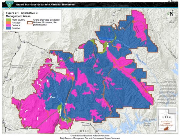
ALTERNATIVE C
Alternative C emphasizes the protection of lands and would only selectively allow for discretionary uses. It divides the monument into four areas — front country area, passage area, outback area, and primitive area. It is the BLM’s preferred alternative and their recent placement of signage in some areas suggests that the BLM has already chosen this alternative.
- Front Country Area (2% of lands) provides for visitation in developed infrastructure such as visitor centers, primary day use sites, highway waysides, overlooks, campgrounds and developed trails and trailheads. Some of these facilities could accommodate larger groups.
- Passage Area (3%) is secondary to Front Country and provides secondary travel routes to other areas and would provide some basic recreational infrastructure.
- Outback Area (35%) would offer motorized access on designated routes, and facilities would be rare.
- Primitive Area: (60%) Undeveloped, primitive land where motorized access is prohibited. Facilities will be nonexistent except for some signage.
- Fourteen special RMAs would be designated where the BLM would only allow recreation that facilitates the special RMA objective (48% of lands under an RMA).
- Target shooting would be prohibited in the Front Country and Primitive areas (65% closed).
- Grazing allotments that area not currently under permit would be closed. Allotments inside Glen Canyon NRA would be closed. Permittees would be prohibited from increasing forage for livestock. 86% of lands would be available for grazing.
- 88,000 acres (5%) of monument lands would be open to noncommercial harvest of forestry products.
ALTERNATIVE D
Alternative D maximizes natural process by minimizing active management and limiting discretionary uses and is most in line with the wishes of conservationists. It would curtail recreation, livestock grazing, rights of way, and activities under special recreation permits.
- Fourteen RMAs would be designated with the fewest acreage covered among all the alternatives (22% of lands under an RMA).
- OHV use would be restricted and road density would be minimized. No areas would be open to OHV use.
- Target shooting would not be allowed anywhere within the monument boundaries (100% closed).
- The BLM would prohibit any new facilities in areas outside RMAs.
- Most allotments within eight “departed watersheds” (meaning, watersheds that have shown a high degree of departure from reference conditions) would be closed. All other allotments will be subject to a land health assessment and determination and fully-processed permit renewals would be required within 10 years. 51% of lands would be available for grazing.
- Vegetation management methods would mostly be limited to natural processes.
- Corridor 68-116 would no longer be designated as a 368 Energy Corridor, and the BLM would manage the most acres of ROW exclusion among the alternatives (91% closed).
- The BLM would manage all land with wilderness characteristics.
– The Byway
Feature image caption: The BLM’s proposed Alternative C as part of Grand Staircase National Monument RMP, mapping out various levels of restriction and accessibility. Courtesy BLM.
Read the Utah bill that was begun in reaction to this monument RMP in New Utah Bill Could Make Grazing a State Right.