Not long after being elected as Commissioner of Garfield County, Dell LeFevre made a trip to a Sierra Club meeting in Ely, Nevada.
LeFevre was a lifelong rancher known for his ability to get along even with those he disagreed with. On this particular trip, he wondered if he might better understand the environmentalists who had worked so long to erode Rural Utah’s agrarian lifestyle.
One of Dell’s friends later recounted that in Ely that day, Dell entered the hotel where the Sierra Club was holding its meetings and walked through the hall toward the meeting room. The hall was lined with the Sierra Club’s displays — but one in particular caught his attention.
It was a map of Sierra’s land goals for Utah. Dell inspected it closely, zooming in on his native Garfield County.
What Dell saw printed there struck him — for all but a mile-wide strip of private land along Highway 89 and the short stretch of Highway 12 to Bryce Canyon, Sierra Club intended the entire county to be designated as a roadless wilderness area!
Of course, this was not an official map of the BLM’s plans or the plans of some other governmental authority. This was just the wish of one environmental organization.
Erase, and Do Over
Decades later, we can’t confirm that this was actually the official plan of the Sierra Club, ever. But it isn’t all that different from the wishes of other environmentalists, who have, first and foremost, an appreciation for the scenic value of this region.
They just forgot, or ignored, the fact that there were people already living here! The land was not quite as much a blank slate as they had thought: it was already peopled, and painted with history and heritage. In a sense, the environmentalists committed the same mistake the federal government had a century before with the Native Americans: they thought the land was blank.
Growing up, I lived and breathed maps. I papered my walls with USGS 7-and-1/2-minute topographic maps of the Uintas and other of the Earth’s “works of art.” Maps were beautiful. Where other teenage boys would have pinned up a poster of Britney Spears, I had a topo map of the Tushars. It’s a wonder I ever got married.
I was also a huge fan of the greatest city planner of all time: Brigham Young. I thought that every city ought to have square city blocks with all streets running north-south and east-west, and named with grid numbers.
Once, while visiting cousins in Wisconsin, I asked why the layout of Waukesha was so messed up. Nothing there made sense! My aunt told me that the whole city started out as cow trails, and they were eventually made into roads. And she added that a lot of other cities were like that too.
I looked at a map of Paris and wondered how much it would cost to straighten out the roads into a Utah-style grid. But in an early hint I might one day wind up an accountant, I also wondered if the benefit of a more efficient city plan would outweigh the cost of erasing the existing city and doing it over.
No, probably not!
Eventually, I grew past Brigham’s square blocks and began to appreciate the historical nature of the unplanned development of land. It was messy and organic. I also began experimenting with drawing up such unplanned cities, simulating how they might grow over time. These were beautiful too.
Thus it is with most of the world. Had America’s Founding Fathers had a bit more foresight about what lay in the vast tracts of land south of the 49th parallel, they could have planned it out better while it was still “blank.” Had they our 21st-century sensibilities, they could have platted the cities, zoned whole regions for agriculture or manufacturing, and straightened out the interstate highways.
Then they could have made the entire Utah territory a roadless wilderness area. You know, for future generations, to [not] enjoy.
But it was not so. By the time civilization progressed and priorities became more enlightened, as some would suppose, the whole country had been peopled.
Born a couple centuries too late, today’s environmentalists now wish to make straight the streets of Paris.
First Come, First Serve
Actually, environmentalists come thousands of years too late to preplan the development of truly “blank” land. There is disagreement on when the first Paleo-Indians crossed the Bering Strait into the Americas, but some scientists believe it was at least 15,000 years ago, when the ice of the last glacial maximum had literally broken.
Since that time, land was gained and lost by tribe after tribe through conquest. This fact poses serious challenges to proponents of reparations, who have only asked to right the societal wrongs of the last 400 years — not the last 15,000! What a mess!
The mess was on full display last July when Ben and Jerry’s, the ice cream company, posted on Twitter that the U.S. was founded on stolen land and that we ought to return it. The tweet sparked an argument between two nearby bands of the Abenaki Nation, both claiming ownership of the land under Ben and Jerry’s very own Vermont headquarters.
Like Ben and Jerry’s, many Americans live on land they purchased from someone else. These are real property rights that must be honored under our current laws. Not only do people have ownership of such private land, but people also own rights to use certain lands they don’t own outright. That’s true with both the tenant living in an apartment building as well as the rancher running cows on public land under a grazing lease.
In America, whoever has the right first, gets to keep the right until she grants it to someone else. And that right is senior to all subsequent rights. As with real property, rights are nearly impossible to legally strip from someone. If these property rights weren’t so strong, the environmentalists would have had us all removed from the Colorado Plateau already!
An Attack on Access Then
In my experience, the vast majority of tourists in our area are respectful of the locals and grateful for the opportunity to see the land we love so much. But a handful seem resentful that we even live here.
Maybe once upon a time Garfield County could all have been made a publicly-owned, roadless wilderness area, but there is still 3% private land here with people living on it full time. Locals also own rights to use much of the public land here. Too often non-locals don’t understand how this works, and actively work to attack those rights.
Short of being able to lobby the government to strip these existing rights, environmentalists have taken to other measures to undermine them through harassment, negative press, and especially by trying to limit locals’ access to exercise their rights. This was apparent, for instance, when President Bill Clinton acknowledged existing rights in the first proclamation of Grand Staircase-Escalante National Monument in 1996.
Clinton would later acknowledge the main reason for the monument designation was to stop Andalex Resources from developing its coal mine there. Even though Andalex still retained the right to mine, the tactic that prevented it was that the BLM made development of the necessary roads to Andalex’s claims impossible. In other words, access had essentially been stripped.
Utah’s school trust lands experienced the same problem with 177,000 acres embedded in the new monument. Because restrictions to access made development of their resources impossible, both Andalex and Utah SITLA opted to sell out of their lands inside the monument.
Access as a Right
In the September issue of The Byway, we went through great lengths to properly present the concept of local land stewardship and the beliefs behind that concept. I think the idea of the Manifesto for Local Stewardship was a plea to let the land be managed by the people closest to it.
Over the last few weeks, however, my thoughts have shifted more to the concept of access as a right. We’re speaking of public lands here, and my belief is that the public needs access to it. In fact, I’m beginning to think of the conservationists’ efforts to restrict access to public lands as one of the greatest threats to public lands — in a way that defeats its entire purpose (beneficial use).
And no, don’t let them tell you that “hiking in” is good enough access — that doesn’t work for campers, and that wouldn’t work for Andalex. Especially if the wilderness area were the size of Garfield County! The appropriate form of access is the form of access in historical use — because historical use constitutes a right. That is what should not be taken away.
I have not always been a proponent of access, however. At least, not consciously. I can credit the people here in Escalante, particularly Commissioner Jerry Taylor, who taught me this principle. I remember one conversation with Jerry a couple years ago — I can’t remember the details, but I said something like, “If the BLM isn’t going to take care of this road, then why doesn’t the county just block it off?” Jerry responded, “No, we don’t do that!”
Ranchers were some of the first settlers to use the lands that are now public lands, and since, other users have enjoyed access to, and the use of these lands. I don’t hear cowboys complain that they have to share the land with all these other users. It’s just part of the local ethos that the land is supposed to be shared by all.
The modern-day conservationist, however, is vying for other users (besides themselves) to be restricted from accessing the land.
I get it, all right? I love this land, and personally, I don’t care to share it with the crowds. In that sense, I am not motivated to market tourism.
But stepping outside what I want personally, I am a proponent of access for all because that is what is best for society. It is also what is fair. If I am willing to fight for access for myself, I also need to fight for everyone else’s access.
It is time, then, I think for all the users of public lands to stop fighting each other for any exclusive access for themselves, and instead join arms to defend access for everyone. Camper van people and ranchers can respect each other’s space out there — and still appreciate that it belongs to all, and appreciate the joy it brings to all.
– by AJ Martel
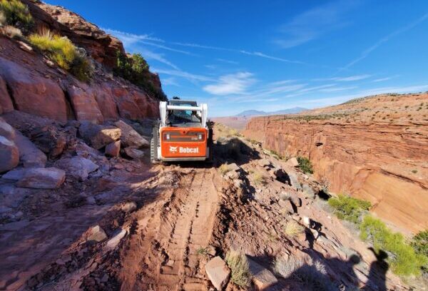
Feature image caption: The Garfield County roads crew works on the upper switchbacks of BLM 15060 to provide an alternate access from Highway 95 south of Hanksville to The Big Ridge, just west of the Glenn Canyon National Recreation Area boundary. Courtesy of David Dodds, June 2021.
Read more about how lawmakers fight for access in Is More Signage a Good Solution to Keeping Access to Dirt Roads?
AJ Martel – Escalante
AJ Martel is the youth coordinator at The Byway, but he is involved in most everything. He and his family live in Escalante, and they love it here! AJ has found Utah’s small towns quite inviting and under-defended, which is why he’s so involved with the paper. What AJ loves to do most, though, is serve his community. That is clear through everything he writes and does for Escalante, Utah.