In the early half of this winter’s snowpack, the mountains are ahead of schedule across Utah.
Following last weekend’s New Year storm, snowpacks across the state spiked. At the beginning of January, basin-wide totals show that for the Fremont, Escalante and Upper Sevier, snowpacks were over 160% of average, with more scattered storms in the immediate forecast.
So early in the season, however these percentages don’t mean much and can change drastically with a single storm, or a single dry week.
The current above-average snowpack face some future headwinds, however.
The Climate Prediction Center states that during November, La Niña conditions persisted over the southeast Pacific Ocean. Their models indicate that these conditions will likely continue through February or March.
La Niña, which is the opposite of El Niño, occurs every few years in a cycle when cooler water surfaces in a long band between Samoa and Peru. The pattern affects weather around the globe. Here in the United States, La Niña winters are typically warmer and drier in the south, and wetter and cooler in the north.
Locally La Niña winters are loosely associated with warmer, drier weather, which means we could have long periods of no precipitation.
Last winter was similar with a good burst of December moisture that put us above average by January 1, but then it didn’t snow again until mid-February!
Climatologists use the national SNOTEL system to predict spring runoff and reservoir refill for much of the western United States. For Sevier River, perhaps the most important SNOTEL station is Midway Valley, at the top of Cedar Mountain just south of Highway 14. Unlike nearby Castle Valley and Brian Head SNOTELs just to the north, Midway Valley is favored most by southern storms and experiences its highest rate of precipitation during March, April and May.
The Midway Valley SNOTEL measures snow depth, but more importantly, the snow’s “water equivalent” depth in inches. In a normal year, it peaks at 24.3 inches on April 13. In 2022, it peaked on April 1 at just 17.2 inches. The worst year since 1981 was in 2002, when the station peaked at a mere 10.7 inches.
On the other hand we can wish for a repeat of 1983 when Midway Valley had 50 inches of snow water — or better yet, 2005, when the station recorded its highest ever snow water equivalent at just over 70 inches. That year, cabins and roads up Mammoth Creek were flooded and the Sevier River cut into fields and pastures down to Panguitch.
– The Byway
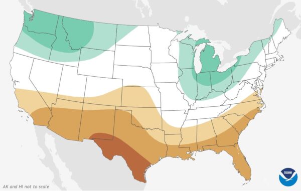
Feature image caption: The Climate Prediction Center’s 2022-23 Winter Outlook for precipitation. Green areas indicate a greater chance of above average precipitation while yellow areas are more likely to be dry. Courtesy of NOAA.
Read more about the effects of this great snowpack in High Snowmelt Brings Flooding across Utah.