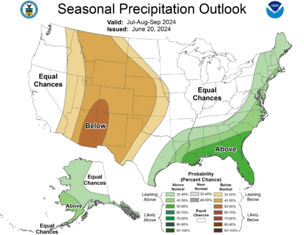
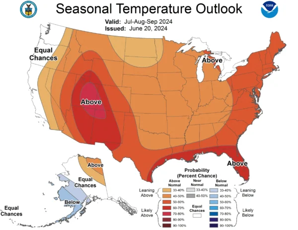
Long range weather forecasts look to be hotter and drier than normal.
The National Weather Service’s Climate Prediction Center, which forecasts general weather trends for 12-month periods, predicts the Four Corners region will experience a hot summer. It also casts doubt on whether we will get our regular surge of monsoon moisture from the south.
NOAA’s July-August-September temperature map shows a hot bullseye right over Eastern Utah and Four Corners. Forecasters note that this prediction comes with higher confidence than normal.
However, “the precipitation outlook over CONUS is less confident than the temperature outlook,” forecaster Cory Baggett noted in late June. “Over the Desert Southwest, most dynamical model guidance is forecasting a weaker southwest monsoon, leading to enhanced below normal probabilities there.”
Unlike the typical seven-day weather forecast that models incoming weather by looking at the weather west of us, seasonal forecasts follow a different set of rules. To bake uncertainty into predictions, the Climate Prediction Center only forecasts the probability temperatures (and precipitation) will be above or below normal.
Normally under the model, an area has a 33% chance of being below average and a 33% chance of being above. For this summer, the Byway region has a 50% chance of having above-average temps in July. That figure increases to 70% by August.
Long range forecasts for the North American CONUS first look at sea surface temperature “anomalies” (as in, how different from normal) in the equatorial Pacific to see whether El Niño or La Niña conditions prevail. Currently, these “ENSO” anomalies there are at zero, meaning a neutral condition and therefore not a factor in the forecast.
ENSO cycles over a period of a few years.
Then forecasters look at other shorter-term oscillations in weather patterns over the tropics, then look at anomalies in other sea surface temperatures and soil moisture across the continents. They then factor in long-term trends they see, as in, the climate change trends over the last 30 years.
After summer, the dry and hot forecast doesn’t seem to change much, with forecasters saying Utah has a higher chance of above-average temperatures and below-average precipitation through next winter and spring.

– by AJ Martel, The Byway
Feature image caption: NOAA shows that above-average temperatures are more likely across almost the entire nation for July, August, and September. Courtesy of NOAA.
Read more about monsoons
AJ Martel – Escalante
AJ Martel is the youth coordinator at The Byway, but he is involved in most everything. He and his family live in Escalante, and they love it here! AJ has found Utah’s small towns quite inviting and under-defended, which is why he’s so involved with the paper. What AJ loves to do most, though, is serve his community. That is clear through everything he writes and does for Escalante, Utah.

