Floods have been all over the news lately. Nationally it’s a lot of what the West, specifically Utah and California, has gotten attention for this spring. But these are large states, and though flooding is a concern for all of us, Southern Utah is more focused on the monsoon season.
One reason is that the climate between Northern and Southern Utah is very different. Not to mention the population and economy. That’s why, as another Byway journalist wrote in an earlier article, Southern Utah is welcoming the spring runoff!
The real concern is the monsoons that come later.
‘A Tale of Two Regions’
Interestingly the flooding concerns in Northern Utah have brought some attention to the regular flood potential in the Southern part of the state.
In an article titled, “A tale of two regions,” ksl chronicled the “extensive damage” from flooding, avalanches, and landslides in Northern Utah, causing Governor Spencer Cox to declare a state of emergency. The article then wondered, if the north was experiencing so many problems from this, why was it still not leading the state in snow water equivalent levels?
The upper Sevier River region is experiencing a 244% increase in snow water equivalent levels, which is pretty similar to that of Provo and Ogden. The Escalante and Paria rivers region is at 277%, while Southeastern and Southwestern Utah have reached 379% and 339%.
Why Is Southern Utah Different?
On average in Southern Utah we have more snowpack runoff, and some flooding, but the flood danger isn’t as high. Why? Erich Mueller, a hydrology professor at Southern Utah University explained the difference. It’s the monsoon.
“Really, the streams in southern Utah are more prone to flooding during that monsoon period and just the snowmelt alone isn’t likely to lead to any significant or widespread flooding,” Mueller told ksl. Because of the monsoon season, the creeks in Southern Utah can handle much larger floods.
One exception, as we know, is the Sevier River by Hatch, in Garfield County. That part of the river runs through a low, flat floodplain, and it could potentially damage farm fields and homes in the area.
Southern Utah’s Monsoon
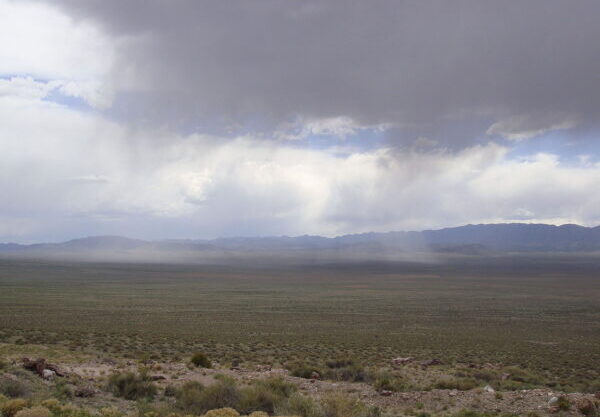
Our monsoon season, known as the North American monsoon, or the U.S. Southwestern monsoon, runs from June 15 to September 30. It is a season of heavy afternoon rains brought up mostly from the Gulf of California. The increase in moisture results in summer thunderstorms at high elevations in Mexico, Arizona, New Mexico, California, and Southern Utah.
Rivers and washes that are normally dry or empty fill up to raging water levels during this time, and flash floods are common. For the most part, though, Southern Utah can handle it. The concern this year is for a rain-on-snow event, or if the snowpack gets rained on, compounding its effect.
“The snowpack is definitely great news in terms of our overall water supply, our overall soil moisture and, you know, potentially helping to even replenish some of our aquifers,” Mueller said.
“If we can get past that rain-on-snow period, you know, the snowmelt is going to be pretty welcome here for the next couple months and hopefully, if it melts slowly, should be pretty minimal in terms of causing any flooding issues.”
– The Byway
Feature image caption: A monsoonal rain cloud hangs over Southern Utah’s Wah Wah Valley in Beaver County. Courtesy Qfl247 at English Wikipedia.
Read more about Southern floods in Are Flash Floods Common in Capital Reef?
Read about why the monsoon may not stay true for 2024 in No Monsoon This Year?