The 2024 water year is off to a slow start for the entire West.
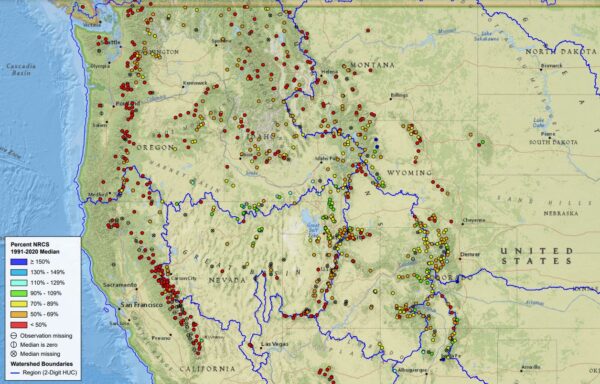
The water year, which begins each October 1, is tracking slow across Utah and other western states, according to SNOTEL stations monitored by the Natural Resources Conservation Service. The NRCS monitors over 900 remote SNOTEL stations in high-elevation locations which record snow depth, snow water equivalent (SWE) and temperature on an hourly basis. Of the 900 stations, 147 are in Utah.
After some storms in mid-November, precipitation across Southern Utah has been limited with temperatures running warmer than normal. As of the end of December (before this weekend’s storms), the Fremont watershed was around 60% of normal, and the Escalante watershed was at 32% of normal. The Agua Canyon SNOTEL (Paria) was at 9%.
On the Panguitch side, the Midway Valley SNOTEL on Highway 14 measured just 43% of average with 3.5 inches SWE. Last year at this time, we had just experienced a significant storm that pushed Midway’s SWE to 16 inches SWE. The April peak SWE for 2023 was a whopping 50 inches, well above the median peak of 24.7 inches. That snowpack sent the Sevier River over its banks during the spring runoff.
State-wide the December 31 snowpack was at 69% of normal.
“It’s early in the season, and I’m hopeful Mother Nature will deliver some much-needed snow, but we are planning for all possibilities,” Candice Hasenyager, director of the Division of Water Resources, said in a statement. “We need to be vigilant to changing conditions and ready for whatever amount of snow the state receives from now until April.”
Utah’s reservoirs are 78% full — much better than last year. Both Piute and Otter Creek reservoirs are about 84% of capacity, and Panguitch Lake is at 87%. Lake Powell is at 35% of capacity, which is 131 feet below full pool (still 44 feet higher than one year ago).
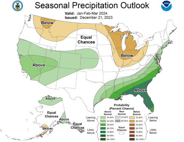
Even with a dismal start, we are only halfway through the water year, and even if we are now in catch-up mode, the water year can still end near normal. The National Weather Service’s Climate Prediction Center, which makes long-range weather forecasts, predicts a higher probability that precipitation will be more than average for the Desert Southwest.
The Climate Prediction Center’s long-range forecasts rely heavily on the ENSO forecast, which looks at the global weather effects of the El Niño/La Niña cycle. El Niño conditions are associated with higher precipitation in the Southwest. El Niño conditions are expected to persist through March, after which NOAA predicts central-eastern Pacific conditions will become “ENSO-neutral.”
– The Byway