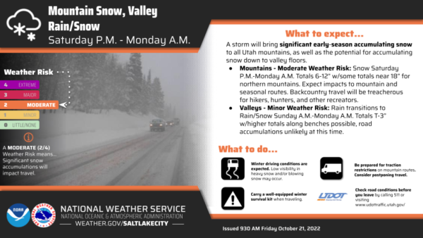
Early Friday morning the National Weather Service issued a moderate winter storm warning for the weekend, expected to last from 6 p.m. Saturday until 6 a.m. Monday.
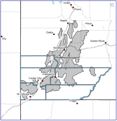
The warning said to expect heavy snow reaching 6 to 12 inches in the mountains of Beaver, Washington, Iron, Kane and Garfield counties.
“Heavy snow will result in winter driving conditions, especially for seasonal routes and mountain passes,” the alert added. In other words, no driving up Cedar Mountain for the leaves — you won’t be able to see them anyway.
It also warned that the snow would make backcountry access treacherous, especially warning the many visitors we receive in these counties, such as hikers, hunters and other recreators.
Wind Advisory
NWS also issued a wind advisory for Saturday afternoon and night, covering Garfield, Piute and Wayne counties, among others.
Winds could reach 20 to 30 mph with gusts up to 55 mph. A few power outages are possible.
As a precaution, secure outdoor objects, including Halloween decorations.
If You Travel, Be Prepared
In connection with the winter storm warning, NWS advised travelers to keep a “well-equipped winter survival kit” in the car. This kit could include essentials such as an extra flashlight, boots, food, water, and a first-aid kit.
In addition to keeping a survival kit, make sure to check your car for maintenance issues and take driving slow.
Windy and snowy conditions make driving a little bit harder. Account for it.
Check this St. George News article for more precautionary and preparedness actions.
– The Byway
Feature image caption: Be prepared for winter driving. Courtesy National Weather Service.